Welcome to the Repton Village History Group.
Here you will find a description of the RVHG, including a brief outline of the activities of the group and details of many of the interesting historical facts associated with this ancient community.
Click here for the latest articles and website updates: Latest News
An Early History of Repton – by Quinton Carol
When I first visited Repton as a prospective pupil in 1982, I was walked along the access to the Hall alongside the church. I saw around the crypt of the church the coverings and trenches of the Biddle’s archaeological excavations. I asked my guides for the day what was going on, and was told that this was where the archaeologists were digging and that we shouldn’t go anywhere near it.
Over my years at Repton, the excavations undertaken by the Biddle’s each summer grew larger and it almost became part of the routine to see how much work had been done before the start of each school year, along with the annual talks given to the school. One particularly memorable year, the excavations in what had been the Headmaster’s garden had left a substantial and deep hole, right on the other side of the wall to the playing yard of the Hall. We lost many footballs and tennis balls that year, as the blanket ban on disturbing the archaeology remained in force.
Looking back nearly 20 years later as a professional archaeologist, the significance of the those excavations remains strong, Anyone who studies Anglo-Saxon archaeology or church archaeology will have heard of Repton, Martin Biddle and Birthe Kjolbye-Biddle. This is not a site report on the Repton excavations. It is to show to my generation of Reptonians what was going on under those covers and sheets, and hopefully explain why we could never retrieve our tennis balls. To those not of our generation this article is intended to demonstrate the archaeological significance of Repton School, and what the discoveries there have meant.
There are many aspects of Repton School that imply some antiquity. Many of the main school buildings date back to the school’s origins as a monastic institution, and the ruins of others can also be found. The church of St Wystan is visibly mediaeval in date, and the village itself has a market cross of similar date outside the school grounds. However the story of Repton goers back further.
Repton village lies on the edge of the floodplain of the River Trent. In times past, rivers formed the major lifelines for settlements as they provided water, transport and fishing for food, all of which was essential for survival of a settlement. Repton also has another attractive feature: its geology. The village is built on a band of gravels that overlie impermeable marls. This combination gives rise to many springs in the area.
The earliest evidence dates from the Mesolithic and Neolithic (5000-2500BC). Remains of flint tools and other were found a round the church, and cropmarks from the area around the village show Bronze Age ring ditches and barrow remains. Archaeological remains of this date are far more prevalent from the north of the river, where excavations near Willington have revealed a settlement area occupied from the Neolithic through to the Saxon period, and other cropmarks indicate extensive remains survive on the gravel terraces.
Into the Roman period, whilst no direct evidence of Roman structures has been located, excavations in ands around the village have found scatters of Roman pottery. This may well have been spread through a practice known as manuring: this involved the spreading of domestic midden (rubbish) deposits on the fields to act as fertiliser, similar to modern composting. Such rubbish deposits invariably include remains of broken domestic pottery, which also become spread on the fields. Pottery scatters resulting from manuring can be distinguished from those located next to settlements by the size and nature of the pot sherds, with manuring shreds invariably being smaller and more worn.
Other Roman finds from around the village include tile sherds and a supposed column base found in the churchyard in 1968. These would suggest the presence of a large, villa type building in the vicinity, although this cannot be confirmed. Common farmsteads dating from the Roman period were excavated as part of the large-scale excavations around Willington.
The main archaeological significance of Repton, and certainly that which has attracted and continues to attract scholars, is the presence of the Anglo-Saxon monastery and church here. Repton is mainly known for the crypt of the church of St Wystan, which dates from the 8th century, and is one of the few Saxon crypts extant today <<PICTURE 1>>. The church itself is one of the most interesting in the county, and has fortunately been the subject of various programmes of recording and excavation.

The history of Repton in this period is closely linked to the Anglo-Saxon kingdom of Mercia. After the initial period of the Saxon migration and settlement, the new arrivals developed political territories in the form of kingdoms. The politics and practicalities of these varied according to the strength of individual rulers, by the arrival of the Christian missionaries in 597AD, those remaining were more stable polities, and collectively known as the Heptarchy. The most significant of these kingdoms were Wessex, Kent, East Anglia, Northumbria and Mercia.
The kingdom of Mercia originated at some point in the 6th century. The name Mercia comes from the Old English meaning ‘border’ and refers to its location between the eastern lands settled earlier and the native British. During the 7th century, under the warlike king Penda, it’s borders rapidly expanded, until it stretched almost from the Thames in the south, the fens and Lincolnshire in the east, the Severn and the Welsh mountains in the west and the Humber in the north. Derbyshire was firmly part of Mercia, and the Trent Valley was densely settled area, and a heartland of the kingdom.
The early Saxon period is reflected by the discovery at Willington of a small agricultural settlement of three sunken feature buildings, with associated pits and pottery. Despite a reasonably large excavation, there was no evidence of post-hole building, but the great halls excavated at Catholme are a short distance upstream. The construction of the road between Repton and Willington over the river Trent in the 19th century revealed human remains, probably from an Early Saxon inhumation cemetery.
There is no firm evidence of the Early Saxon period at Repton itself, and it is not until the Middle Saxon period that the focus of activity appears to shift across the river from Willington to Repton. During the Roman period this area appears to have been mainly a quiet agricultural area focused along the River Trent. A fort and vicus existed at the cross roads at Littlechester near Derby, and a road from here to Wall (near Lichfield) ran along the line of the modern A38, very close at least to Willington. However the road avoids having to cross the River Trent, so no focus existed for settlement in this area.
The first reference to Repton is questionable and depends upon an interpretation of the Anglo-Saxon form of its name. It is recorded in the later Saxon period and Domesday as Hrepandum but an unlocated place name called Hrepingas occurs in various early charters. Stenton has argued etymologically that Hrepandum and Hrepingas are the same place, although it must be said that this view is not universally accepted. Sawyer, for example, places Hrepingas at Rippingale in Lincolnshire.
Taking as accurate the interpretation of Stenton, then Repton appears as an early possession of Peterborough Abbey in Cambridgeshire. The infamous charter Sawyer 68 which purports to list all Peterborough’s possessions as a confirmation by Wulfhere of Mercia in AD664 has Repton on its list. However, this charter is a forgery, and dates from the 10th century when the monks of the refounded institution were attempting to legitimise their holdings by claiming historic precedent. Nevertheless, it is generally accepted that the charter has an authentic basis, and that it may well represent a list of Peterborough’s 7th century holdings.
A more authentic mention of Repton is in a charter dated between 675 and 692AD, from Friduric, a princeps of Mercia to the abbot of Breedon on the Hill in Leicestershire (Sawyer 1805). This grants land at Hrepingas to Abbot Haedda. An earlier although more dubious charter from Friduric grants land at Breedon to Peterborough, so again a link between Repton and Peterborough can be established (Sawyer 1803). If so, then this first charter may well be the foundation charter of Repton Abbey.
Peterborough Abbey (or Medeshamstede as it was still called) was a foundation of the Mercian royal family, and so its daughter houses would have had royal connections. By the eighth century, Repton Abbey was most certainly a royal house. It appears to have been either a double house (men and women) or women only, for the Life of St Guthlac states that the saint was tonsured by Abbess Aelfthryth prior to 700AD.
Although a royal house, it is important to realise the nature of Saxon kingship at the time. It is unlikely that any king had what we would regard as a capital. What is more likely is that kingship was peripatetic, with the ruler and his court/followers travelling from centre to centre, living of dues and foodrents. Places like Repton would have had such a function.
The excavations that took place around the church from 1974-1993 have only recently been published in an interim form. These demonstrated the development of the site and its transition from a Middle Saxon church to a mediaeval monastery. The earliest structural evidence was a drain dating from the 7th century to the north of the crypt, and it is suggested that the earliest church of the abbess of Repton, founded in the 7th century, lay outside the curtilage of the later structure. The first element of the current church is the crypt, the exact dating of which is disputed but a Middle Saxon date is certain.
Much of the evidence of Saxon activity at Repton comes from the cemetery and its sequences. The excavators identified five distinct areas of burial, the earliest of which dates from the 8th century and lies to the north of the current church, so south of its predecessor. This cemetery had two phases. Later burials associated with the Viking occupation of Repton in 873/4 AD were centred on a stone built structure that appeared to date from this earlier phase <<PICTURE 2>>. Initially opened in the 17th century, within this structure was a single male Scandinavian, furnished burial dated from the Viking occupation. The recent excavations uncovered the charnel remains of some 264 individuals, radio-carbon dated by extensive sampling to two phases, one 8th century and one late 9th century.
The excavators have interpreted this structure as a reused high status funerary mausoleum from the Mercian period of Repton, that was reused for a high status burial during the Viking occupation. At the same time, the bones of its earlier users were placed in it, perhaps symbolically to represent the overlordship of the recently deceased. It has been suggested that this is the burial place of Ivarr the Boneless, a renowned Viking warrior, but this is conjectural. The structure lay outside the enclosure that was dug by the Vikings and incorporated the church, now in its current location. There were also burials from this Viking period to the north of the church, the fill of which contained burnt material suggestive of the ransacking of the church.
After the Viking occupation, the mausoleum structure formed a focus for a 10th to 12th century cemetery, and further burials of this period are known from north and south of the church. The area between the mausoleum (in the Vicarage garden) and the church was not excavated, but it would be reasonable to suggest that they are two components of the same church cemetery, although it is odd to find an earlier structure being a focus for burials in the Late Saxon period, as this practice is more common in the 7th century, when earlier often prehistoric barrows were used as foci for Anglo-Saxon cemeteries.
These excavations provide a full description of the development of Repton during the Middle Saxon period. Quite apart from the Viking element, they uncovered evidence of structures to the north of the church, that appear to date from the 7th and 8th centuries. That would make them contemporary with the first references to the abbey, and would locate such an institution on the immediate banks of the River Trent. Finds of Ipswich ware and other items of value and status suggest a wealthy centre here. With the arrival of the Vikings, an encampment was built on the riverside <<PICTURE 3>>. This took the form of a D-shaped enclosure on the river with slip-ways and settlement inside.
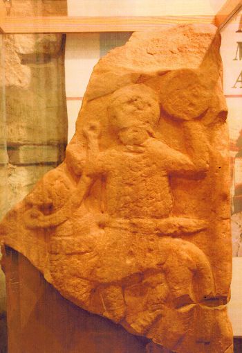
The earliest Saxon element of the current church is the crypt. However this is of more than one phase, and the exact dating of it is uncertain. At some point in the 8th century a simple, square chamber was constructed below ground, with a western entrance, presumably as a burial chamber. According to the Anglo-Saxon Chronicle, King Aethelbald of Mercia was buried here in 757AD after his murder at Seckington close by, so it is possible that a burial chamber was constructed for one of the most powerful kings of his day. A carved stone from this site include a slab with a carved figure and elements that appear to be of the name ‘Aethelbald’ have been associated with this king <<PICTURE 4>>.
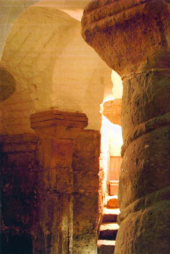
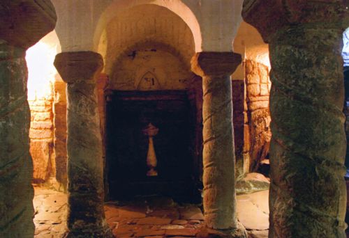
Only the lower parts of the crypt walls are of the earlier dates. At some point, probably in the earlier 9th century, it was again remodelled. Florence of Worcester, writing in the 12th century about St Wystan, states that the saint was buried in the mausoleum of his grandfather Wiglaf at Repton; Wiglaf died in 839AD. The remodelling that took place appears to have had two components. Firstly the roof was rebuilt into the vaulted form it has today, and the supporting columns inserted. The barley twist relief pattern on these columns is supposedly based upon the columns and arcades of St Peter’s Church in Rome, and it is recorded that various Mercian nobles and royalty had visited the Holy City <<PICTURE 5>>.

The second change was to ease access into the crypt, and this is what helps to date it. The original entrance was a single stair to the west, presumably as steps down from the church above. This was blocked in, and two stairs into the north-west and south west corners were punched through the stone work into the crypt. This in effect creates a system for the through-put of people, as they enter through one stair and leave through another <<PICTURE 6>>. This increase in monumentality of the crypt and the ease of access suggests that it became a centre for pilgrimage at some point, and the obvious candidate for such veneration would be St Wystan, thus dating these works to the mid 9th century. This date would tie in with the rise in saints’ cults in Middle Saxon England.
An alternative view to this was recently put forwards by Eric Fernie, the architectural historian. Fernie feels that Repton actually has four phases and not two. He argues it originated as a freestanding burial chamber in the first instance, probably in the 7th or 8th century – it is known that Repton was the burial place of Mercian royalty. At some point, the twisted columns were inserted (which Fernie claims were copied from similar ones from Utrecht, although Rodwell believes them to be a copy of wooden barley twist decoration), and a mausoleum built over the crypt, and the burial place became a cult centre for Wystan, and thus saintly and not secular. Fernie ascribes three phases to this transition, and dates them after 850AD. Given that Repton was destroyed by the Vikings in 873/4, he suggests that these phases may date to after the reconquest of this area in c.920, and before the relics of Wystan were moved to Evesham in 1020. In other words, this would place the construction of the cult centre to some 100 years after the death of the saint. The Biddles in their recent excavations do not support this, but the existence of these arguments serves to illustrate the importance of this site.
The nature of the above ground remains contemporaneous with the crypt is uncertain. The western staircase of the original crypt suggests a simple building that may not have even overlaid the crypt itself. This gradually became more elaborate, and comprised a central area to the west of the crypt, square in form, a chancel over the crypt, nave further west and two possible transepts, in other words a cruciform church. However, not all the components of this cruciform shape may be contemporary. It is notable that the redesigned entry and egress to the crypt would bring the visitors away from the central ritual area of the church, and it is feasible that this was done deliberately to keep them outside. It should be remembered that prior to St Wystan, this had been primarily a private burial chamber, so it is quite feasible that the response to the creation of a saint’s cult here was to ensure the pilgrims remained away from the chapel itself.
Much of the development of the floor plan of Repton church can be seen from foundations revealed during restoration in the 19th century. This does indeed reveal the components of a cruciform style church (or a five cell transverse plan, to use Taylor and Taylor terminology). The crossing (or central focus, depending on whether a tower existed) is known to have had round headed arches, and with north and south transepts and a nave, the classic form of a later Saxon church is revealed. In addition, the chancel walls show the remains of pilaster strips on the outside.
The figure below shows an indicative floor plan of the church. The outline in red represents the known Saxon church, with the location of the crypt highlighted in blue. The black broken lines are mediaeval or later additions, but the outline of a Late Saxon cruciform church is clearly evident.

It is difficult to argue an accurate dating sequence without being circular. Taylor and Taylor claim a 9th century date for the chancel and crossing, but admit that this would be a very early example of pilaster decoration, which they then argue originated in the 9th century because of its presence at Repton. Other known examples are mid to late 10th century in date. It has to be said that the majority of examples of cruciform churches, pilaster decoration, circular columns and bases and long-short work (also seen at Repton) are indeed dated from 950AD onwards, and usually at sites with a royal or very high status connection – such masonry is expensive!
After the departure of the occupying army in 874AD and the subsequent end of the Mercian royal family, the site so long associated with the rulers of that kingdom also faded, and there is no further reference to Repton until the Domesday survey. The surviving Anglo-Saxon fabric of the church is likely to date from the 10th century, and would be appropriate for a building repaired and turned to pastoral use rather than as a religious house. In Domesday, Repton gave its name to the Wapentake for the area, and was probably an important local centre. The principal manor had been held in 1066 by the Earls of Mercia – Domesday records Earl Algar as holder, but he died in 1063 and was succeeded by his son Edwin, who is seldom recorded in the survey.
The evidence for the Late Saxon period identifies Repton as a centre of some prominence. The church building itself is evidently the result of considerable expenditure of resources, for cruciform churches with pilaster decoration are not cheap structures, and in Domesday the manor is recorded as having two priests for its church. It also possessed berewics at Milton, Ingleby (site of a Viking barrow cemetery) and Ticknall. It was owned by the earl of Mercia, one of the most powerful individuals in the country, and became a possession of King William after the death of Edwin in 1071. This is a secular estate centre for the surrounding area, and evolved in the mediaeval period as a typical linear settlement along the main roads to the south and east, with peculiarities seen to the north.
Within the current streetplan, the churchyard can be identified, as can the priory to the east, but the layout suggests a surviving enclosure that included the church, part of the priory identified as the priors’ area, and land to the west up to the road, fronting onto the River Trent. Certainly the excavations here located a substantial enclosure ditch associated with the 9th century and then used as part of the Viking encampment, so again there is a strong suggestion that the perimeter of the middle Saxon church site or central place is fossilised in the street plan.
After the fall of the Mercian kingdom in 874AD and the flight to Rome of Burgred, its last independent king, the last surviving kingdom was Wessex under Alfred the Great. The West Saxons finally defeated the Kings in 878AD and subsequently signed a peace treaty that divided Mercia into two, using Watling Street as a border. The Viking area was called the Danelaw and included Repton. Rulership of Saxon Mercia passed to Aethelred, but he used the title Ealdorman of Mercia, and recognised the overlordship of King Alfred of Wessex, whose daughter he married.
Aethelred took part in the gradual reconquest of Mercia from the Vikings. He died in 911AD, and the rule of Mercia passed to his wife Aethelflaed, who became known as the Lady of the Mercians. She continued the campaign at the head of the Mercian army and in 918AD recaptured Derby. She died shortly afterwards, and her brother Edward the Elder, king of Wessex, fearful of Mercian independence, took her only daughter and heir back to Wessex to prevent her becoming a focus for anti-Wessex sentiment. Her name was Aelfwynn, and with her departure, Mercia accepted its new status as an ealdormanry of the newly created kingdom of the English.
Although many monastic institutions destroyed and abandoned during the Viking raids of the late 9th and early 10th century were refounded or re-established from the mid-10th century onwards, Repton was not one of them. It was not refounded as an abbey until the Countess of Chester endowed an Augustinian Priory here in 1153-9AD, the buildings of which became part of Sir John Port’s School. The remains of Repton’s height in the Middle Saxon period remained hidden until the rediscovery of the crypt in the 18th century and the subsequent archaeological interest in the site, culminating in the work of the Biddles in the 1970s and 1980s.
Quinton Carroll (H83)
Cambridgeshire Archaeology
Cambridgeshire County Council
References
| Alcock, L | The Activities of Potentates in Celtic Britain, AD500-800: a positivist approach | in Driscoll & Nieke 1988 |
| Biddle, M | The Repton Stone | ASE Vol.14, 1985 |
| Biddle, M & Kjolbye-Biddle, K | Repton and the Vikings | Antiquity vol.66, 1992 |
| Biddle, M & Kjolbye-Biddle, K | Repton and the Great Heathen Army | Graham-Campbell, J, Hall, R, Jesch, J & Parsons, D 2001 |
| Blair, J | The Church in Anglo-Saxon Society | Oxford 2005 |
| Blair, J ed. | Minsters & Parish Churches | OUCA Monograph 17, 1988 |
| Blair, J ed. | Pastoral Care Before the Parishes | Leicester 1992 |
| Butler, L | Church Dedications and the Cult of Anglo-Saxon Saints in England | in Butler & Morris 1986 |
| Butler, L & Morris, R eds. | The Anglo-Saxon Church: Papers on History, Architecture and Archaeology in Honour of HM Taylor | CBA Research Report 60, 1986 |
| Carroll, Q | The English Church 597-731AD | unpublished MPhil thesis, University of Cambridge 1997 |
| Carroll, Q | The Role of Ealdormen in 10th Century England | unpublished BA thesis, University of Cambridge 1991 |
| Carroll, Q | The Archaeology of Anglo-Saxon Christianity: A Study on the Churches of Derbyshire and Cambridgeshire 597-1066AD | Unexamined PhD thesis, University of Cambridge 2005 |
| Clemoes, P ed. | The Anglo-Saxons | London 1959 |
| Colgrave, B ed. & trans. | Felix’s Life of St Guthlac | London 1956 |
| Conant, K | Carolingian & Romanesque Architecture 800-1200 (3rd Edition) | Harmondsworth 1973 |
| Derbyshire County Council Historic Environment Record | ||
| Dornier, A ed. | Mercian Studies | Leicester 1977 |
| Douglas, D, Tucker, S & Whitelock, D ed. & trans. | The Anglo-Saxon Chronicle | London 1961 |
| Driscoll, S & Nieke, M eds. | Power & Politics in Early Mediaeval Britain & Ireland | Edinburgh 1988 |
| Faull, M | Studies in Late Anglo-Saxon Settlement | Oxford 1984 |
| Fernie, E | The Architecture of the Anglo-Saxons | London 1983 |
| Fernie, E | The Architecture of Norman England | Oxford 2000 |
| Foot, S | Anglo-Saxon Minsters 597-c.900AD | unpublished PhD thesis, University of Cambridge 1990 |
| Forester, T ed. & trans | Florentii Wigorniensis Monachi Chronicon ex Chronichis | London 1854 |
| Graham-Campbell, J, Hall, R, Jesch, J & Parsons, D eds. | Vikings & the Danelaw | Oxford 2001 |
| Hadley, D | The Northern Danelaw : its social structure, c.800-1100 | London 2000 |
| Hart, C | The North Derbyshire Archaeological Survey | North Derbyshire Archaeological Trust 1981 |
| Hill, D | An Atlas of Anglo-Saxon England | Oxford 1981 |
| Hipkins, F | Repton: Village, Abbey, Church, Priory & School | Derby 1892 |
| Keynes, S & Lapidge, M ed. | Alfred the Great: Asser’s Life of Alfred & Other Contemporary Sources | Harmondsworth 1983 |
| Kinsley, G & Loscoe-Bradley, L | Catholme and the Anglo-Saxon Settlement on the Trent Valley | London 2002 |
| Lane, H | The Romans in Derbyshire | Chesterfield 1986 |
| Lapidge, M ed. | The Blackwell Encyclopedia of Anglo-Saxon England | Oxford 1999 |
| Losco-Bradley, S & Wheeler, H | Anglo-Saxon Settlement in the Trent Valley: Some Aspects | in Faull 1984 |
| Morgan, P ed. | Domesday Book 27: Derbyshire | Chichester 1982 |
| Morris, R | Churches in the Landscape | London 1989 |
| Page, W ed. | The Victoria County History of Derbyshire vol.1 | London 1905 |
| Pevsner, N | The Buildings of England: Derbyshire (2nd Edition) | Harmondsworth 1978 |
| Roffe, D | The Derbyshire Domesday | Matlock 1986 |
| Rumble, A | Hrepingas Reconsidered | in Dornier 1977 |
| Sawyer, P | Anglo-Saxon Charters: An Annotated List & Bibliography | Royal Historical Society Guides & Handbooks No.8. London 1968 |
| Stenton, F | Preparatory to Anglo-Saxon England, being the collected papers of Frank Merry Stenton | Oxford 1970 |
| Stroud, G | Derbyshire Extensive Urban Survey Archaeological Assessment Report: Repton | Derbyshire County Council 1999 |
| Taylor, H & J | Anglo-Saxon Architecture (3 vols.) | Cambridge 1965-1978 |
| Taylor, HM | Repton Studies Vols. 1-3 | booklets 1977-81 |
| Wainwright, F | Aethelflaed, Lady of the Mercians | in Clemoes 1959 |
| Wheeler, H | Excavations at Willington, Derbyshire 1970-2 | DAJ Vol.99, 1979 |
| Whitelock, D ed. | English Historical Documents Vol. 1: c.500-1042 (2nd Edition) | London 1979 |
Images
- Exterior of Crypt. The Saxon architectural features can be clearly seen, and the area to the foreground was part of the excavations.
- Vicarage Garden. The location of the Viking period burial mound
- Headmaster’s Garden. Riverside slipways were excavated in this area
- The Aethelbald Stone. Is this a portrait of a Saxon king?
- Crypt interior. The twist relief on the pillars is clearly seen
- Crypt interior. The additional entrances to the crypt are visible to the left and right.